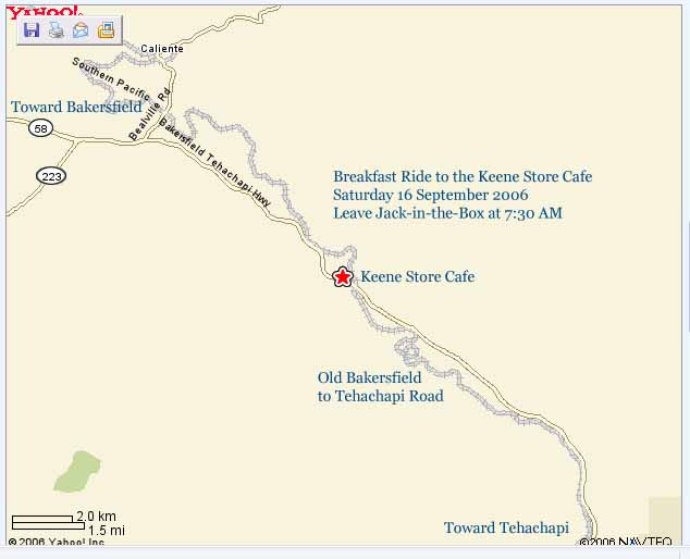
Directions to Keene
Store Cafe
Breakfast Ride 16 Sept 2006
Leave Jack-in-the-Box at 7:30 AM
15 September 2006, 6:30 AM
15 September 2006:
I would like to add some input here regarding this ride. Just off of Hiway 58 and about three miles southeast of Keene is the Tehachapi Loop. If you have never seen the "loop" with a train going through it, it is quite a sight. Here is a little more info.
In addition, I see the proposed route home is through Caliente and over the Lion's Trail, through Havilah and down into Bodfish and the Lake Isabella area. For any of those interested, The Lake Isabella VFW is sponsoring a Poker Run, The Veteran's River Run, on Saturday, September 16th to raise funds for Kern National Cemetary Memorial Park. Ride Safe!!!
~tony~
A World-Famous Railroad Construction Achievement of the 19th Century
Located about eight miles west of Tehachapi, California, near Highway 58
In the 1870's the Southern Pacific (Central Pacific) Railroad sought
to link their rails in central California to those in Southern California.
The path was blocked by the rugged Tehachapi Mountain range, which acts
as
an east-west barrier between Bakersfield and Los Angeles. Since construction
directly south was impractical, the Southern Pacific Railroad decided
to go
southeast to Mojave, through the Tehachapi Pass. The summit at Tehachapi
Pass was 4000'. Construction from Bakersfield to Caliente was somewhat
routine, but from that point on the elevation going east rises quickly.
From
Caliente to the summit (now the City of Tehachapi) the rise is 2,735 feet.
The maximum grade permitted was 2.2%. By routing the track alongside the
slopes of the Tehachapi foothills, engineer William Hood could envision
completing the task. However, just east of Keene, there was an apparently
unsolvable problem. An increase in elevation of nearly 80 feet was required,
unattainable using typical designs.
The problem was solved by constructing a unique loop. Going
southeasterly from Keene, a train first passes through an entry tunnel.
The
track then does a complete counterclockwise loop, passing over the entry
tunnel before continuing easterly. (See sketch below). The loop is sized
to
have a length adequate to achieve the needed gain in elevation. The result
is a loop 3,799' long, with a typical diameter of about 1210 feet. By
continuing to gain elevation throughout the loop, engineer Hood was able
to
make up the needed elevation (about 77' rise in the loop). With modern
freight trains, often more than a mile long, the locomotive passes over
(or
under, depending upon direction) the final cars of its own train!
The entire track from Bakersfield to
the summit was completed July 10,
1876. In all, in addition to the loop, there are 18 tunnels with a total
length of 8,240'. There are 8,300 degrees of rotation as the track twists
and turns through and along the mountains. The total distance from Caliente
to Tehachapi (summit) is about 16 miles.
The construction was undertaken by American
engineers and Chinese
workmen. The Chinese were "Cantonese", mostly recruited from
Canton (now
Guongjhou) area. Construction tools were mostly dynamite, picks and shovels.
Many of the workmen were killed during this dangerous work.
The Chinese workmen referred to the Tehachapi
Loop as "Walong".There
is no such word in Cantonese. Since the workmen spoke no English and the
Americans spoke no Chinese, the English interpretation of Walong could
come
from either of two Chinese expressions.
Dr. Fung Chi-ming of the Hong Kong Museum
of History suggests that
"Wa" = China (or Chinese) and "Long" is similar to
the Cantonese word for
"road". Hence, Walong means "Chinese Road".
James W.H. Wong suggests that "Wa"
could have really been "Wan" = coil
or coiled, and that "Loon" in Cantonese could sound similar
to Long to the
American ear. "Loon" = Dragon. In this case, Walong would be
"Coiled
Dragon", which also seems an appropriate name for the Tehachapi Loop.
The steep grade of the track from Keene
to Tehachapi has always been a
problem for the railroad. In 1882, a special locomotive, "El Gobernador"
was
developed especially for hauling trains to the summit. It proved to be
too
bulky for this service, and after a few years El Gobernador was scrapped.
Today the Tehachapi Loop (operated jointly
by the Union Pacific and
Santa Fe Railroads) is on the main artery joining the agricultural and
petroleum products of the San Joaquin Valley to Arizona and east. As many
as
40 freight trains a day execute the loop, making it the busiest single-track
line in the United States. Long eastbound freight trains cannot negotiate
the grade with a normal locomotive complement, and it is undesirable for
the
couplings between forward cars to support the high tension loads. Therefore,
"helper" engines are inserted in the middle of the train. Upon
reaching the
City of Tehachapi, the helpers are switched out, and then returned to
Bakersfield.
Even as recently as 1950 many passenger
trains stopped in Tehachapi.
The last passenger service was discontinued in 1971. In 1950, "First
Class"
service to Bakersfield took about one hour and 40 minutes. However, using
modern highway 58, one can drive to Bakersfield in 45 minutes. For this
and
other reasons, passenger trains from which to view the Tehachapi Loop
are no
longer available. However, you can vicariously enjoy the ride between
Caliente and the Summit by video tape. An excellent 80 minute railroad
tour,
"Tehachapi", is carried by Tehachapi Radio Shack, 805/822-4512.
The loop carries an enormous amount of
freight daily. It is easily
accessible by auto. Take Highway 58 northwest from Tehachapi (or southeast
from Bakersfield) to Keene. From Keene follow the sign pointing to Tehachapi
Loop. You will pass "La Paz" on the way. (La Paz is the burial
site of Cesar
Chavez, and the headquarters of the United Farm Workers Union). "Loop
Ranch"
is the name of the ranch hosting the loop. It is about three miles from
Keene to the loop along a paved road. So far there have been no problems
in
finding off-street parking while awaiting a train. Be aware, however,
that
freight schedules are not predictable, and there is no guarantee of railroad
traffic frequency.
Continue on about one mile and there
will be a viewsite with two
monuments on your left, looking down on the loop. The first monument is
a
National Historic Landmark. The second monument is a National Historic
Civil
Engineering Landmark (installed 10/10/98). The Civil Engineering Landmark
honors the construction feat of the entire track from Caliente to Mojave.
It
especially recognizes the effort of Southern Pacific Railroad chief engineer
and construction boss J. B. Harris in designing and constructing the line,
whose major feature is the Tehachapi Loop. Speakers at the October 10
presentation were Tehachapi Mayor John Rombouts, civil engineer Warren
Minner, Chuck Kirkland (president of the Tehachapi Loop Railroad Club),
Del
Troy (president of the Tehachapi Heritage League), and Mary Ming,
Bakersfield historian. Mary Ming discussed the brave efforts of the Chinese
workers.
An excellent 300-page book detailing
this railroad construction is
"TEHACHAPI (Southern Pacific - Santa Fe)", copyright 1983 by
John R. Signor.
Golden West Books, San Marino, CA 91108. ISBN 0-87095-088-6. As of February,
1996, this book was out of print, but may be available through libraries.
Yet another bibliographic resource is
TEHACHAPI RAIL MAP AND GUIDE,
Sam Pottinger, Steel Rails West, P.O. Box 59117, Norwalk, CA 90652-0117.
A live camera is set up to photograph
trains as they enter Tehachapi
Loop. For a current photo from Tehachapi Loop click here. (Photo may not
be
useful in inclement weather or nightfall.)
Prepared by J.C. Sammis - 1996. Modified
to show Union Pacific Railroad
instead of Southern Pacific Railroad & added sound. 1998. Added reference
to
Civil Engineering Landmark and to meaning of "Walong", 1998.